WE ARE COMMITTED TO REPORTING THE LATEST FORESTRY ACADEMIC ACHIEVEMENTS

Article Contents
Turn off MathJax

SUN H L, FANG Y H, LI J J, et al. Diversity patterns of ground birds and animals in the erhai basin based on camera traps[J/OL]. Journal of Sichuan Forestry Science and Technology, 2024, 45[2024-03-04] doi: 10.12172/202308220001
Citation: SUN H L, FANG Y H, LI J J, et al. Diversity patterns of ground birds and animals in the erhai basin based on camera traps[J/OL]. Journal of Sichuan Forestry Science and Technology, 2024, 45[2024-03-04] doi: 10.12172/202308220001

Diversity Patterns of Ground Birds and Animals in the Erhai Basin Based on Camera Traps


doi: 10.12172/202308220001
More Information
  • Watershed is an important factor shaping mountain biodiversity. There is strong interaction of matter and energy inside a watershed; Water flow and watershed boundary has a blocking effect on land animals; Human interference caused by towns along water also affect the distribution of organisms. However, there are few studies that discuss biodiversity patterns from a watershed perspective. Thus, this study were did in an area with a long history of human settlement, Erhai Basin. It deployed 120 infrared camera traps from February 2017 to September 2020 to explore the diversity of ground birds and animals in three areas bounded by Xier River - Xiaguan Town, Boluo River - Fengyi Town, and three rivers to the north of Erhai Lake - Eryuan Town, namely Cangshan Mountain, Zhemo Mountain and Jizu Mountain were compared. The cumulative working days in Cangshan Mountain, Zhemo Mountain and Jizu Mountain were 4 004, 5 290 and 2 924 days respectively; There were 947, 2 542 and 675 independent photos separately. A total of 98 species of birds and mammals were identified, including 25 mammals in 17 families of 6 orders and 73 birds in 23 families of 6 orders of birds, including 2 species of national first class protected animals and 17 species of national second class protected animals. In addition to Cangshan Mountain, which is located in a protected area, the non-protected areas of Zhemo Mountain and Jizu Mountain have also found animals of national priority protection. There are no significant differences in bird and mammal species diversity in the three areas. However, all three areas have endemic ground birds and animals, and the analysis of similarities shows that there are significant differences in the composition of birds and animals between the three areas, with the greater differences in the composition of animal species between Jizu Mountain and Zhemo Mountain. Between the sample points have large community differences and high functional diversity in Jizu Mountain than those of the two other areas. We speculate that rivers and towns have already created a barrier for birds and mammals, and the topography and vegetation in different areas might also affect the species differences.
  • 加载中
  • [1] 白玉芳. 山西太岳山脱皮榆群落的物种多样性和功能多样性研究[D]. 太原:山西师范大学,2014.

    Bai Yufang. Studies on species diversity and functional diversity of Ulmus lamellosa Community in Taiyue mountain of Shanxi[D]. Taiyuan: Shanxi Normal University, 2014.
    [2] 王凯,王聪,冯晓明,等. 生物多样性与生态系统多功能性的关系研究进展[J]. 生态学报,2022,42(1):13.

    Wang Kai, Wang Cong, Feng Xiaoming, et al. Research progress on the relationship between biodiversity and ecosystem multifunctionality[J]. Acta Ecologica Sinica, 2022, 42(1): 13.
    [3] 江小雷,张卫国. 功能多样性及其研究方法[J]. 生态学报,2010,30(10):8.

    Jiang Xiaolei, Zhang Weiguo. Functional diversity and its research method[J]. Acta Ecologica Sinica, 2010, 30(10): 8.
    [4] LEADER-WILLIAMS N, OWEN-SMITH R N. Megaherbivores: The Influence of Very Large Body Size on Ecology[J]. Journal of Animal Ecology, 1990, 59(1): 381.
    [5] 杨家伟. 滇西北地区生物多样性保护现状与对策[J]. 林业资源管理,2002(3):61−65. doi: 10.3969/j.issn.1002-6622.2002.03.016

    Yang Jiawei. Status and solutions of biodiversity protection in Northwest Yunnan[J]. Forest Resources Management, 2002(3): 61−65. doi: 10.3969/j.issn.1002-6622.2002.03.016
    [6] 左晓舰. 西南地区流域开发与人居环境建设研究——流域资源环境评价和承载力研究[D]. 重庆:重庆大学,2008.

    Zuo Xiaojian. Study on basin development and Human Settlements construction of Southwest China——Study on systemic appraisal and carrying capacity on resources and environment of basin[D]. Chongqing: Chongqing University, 2008.
    [7] IMMERZEEL W W, LUTZ A F, ANDRADE M, et al. Importance and vulnerability of the world's water towers[J]. Nature, 2020, 577(7790): 364−369. doi: 10.1038/s41586-019-1822-y
    [8] NAIMAN RJ, DECAMPS H, POLLOCK M. The Role of Riparian Corridors in Maintaining Regional Biodiversity[J]. Ecological Applications, 1993, 3(2): 209−212. doi: 10.2307/1941822
    [9] POPESCU C, OPRINA-PAVELESCU M, DINU V, et al. Riparian vegetation structure influences terrestrial invertebrate communities in an agricultural landscape[J]. Water, 2021, 13(2): 188. doi: 10.3390/w13020188
    [10] GASCON C, MALCOLM J R, PATTON J L, et al. Riverine barriers and the geographic distribution of Amazonian species[J]. Proceedings of the National Academy of Sciences, 2000, 97(25): 13672−13677. doi: 10.1073/pnas.230136397
    [11] 冯卫红,刘敏. 基于流域人居环境系统的的晋商文化景观地域差异比较研究——以汾河流域与沁河流域为例[C]//中国地理学会2012年学术年会学术论文摘要集:56-57,2012.

    Feng Weihong, Liu Min. A Comparative Study of Regional Differences in Shanxi merchants Cultural Landscape Based on Watershed Habitat System——Take Fen River Basin and Qin River Basin as an example[C]// The Geographical Society of China 2012 annual academic conference collection of abstracts of academic papers: 56-57, 2012.
    [12] 吴文生. 聚焦我国古代水文化发展[J]. 陕西水利,2004(4):50−51.

    Wu Wensheng. Focus on the development of ancient water culture in China[J]. Shaanxi Water Resources, 2004(4): 50−51.
    [13] STRAYER D L, BEIGHLEY R E, THOMPSON L C, et al. Effects of land cover on stream ecosystems: roles of empirical models and scaling issues[J]. Ecosystems, 2003, 6(5): 407−423. doi: 10.1007/PL00021506
    [14] JEONG S, KIM H G, THORNE J H, et al. Evaluating connectivity for two mid-sized mammals across modified riparian corridors with wildlife crossing monitoring and species distribution modeling[J]. Global Ecology and Conservation, 2018, 16: e00485. doi: 10.1016/j.gecco.2018.e00485
    [15] 涂志华,范志平,王善祥,等. 大伙房水库流域不同水源涵养林土壤微生物量碳氮特征及其影响因素[J]. 中国水土保持科学,2019,17(4):130−140.

    Tu Zhihua, Fan Zhiping, Wang Shanxiang, et al. Soil microbial biomass properties and its controlling factors under different vegetation types of water conservation forests in Dahuofang Watershed[J]. Science of Soil and Water Conservation, 2019, 17(4): 130−140.
    [16] 魏慧玉,陈凯,王备新. 澜沧江流域水生昆虫群落分类多样性和功能多样性海拔格局的空间尺度依赖性[J]. 生物多样性,2020,28(4):504−514. doi: 10.17520/biods.2019359

    Wei Huiyu, Chen Kai, Wang Beixin. The spatial scale dependency of elevational patterns of taxonomic and functional diversity in aquatic insects in the Lancang River, Yunnan, China[J]. Biodiversity Science, 2020, 28(4): 504−514. doi: 10.17520/biods.2019359
    [17] 环境保护部编制. 中国生物多样性保护战略与行动计划:2011—2030年[M]. 北京:中国环境科学出版社,2011.

    Ministry of Environmental Protection of the People's Republic of China. China Biological Diversity Protection Action Plan: 2011-2030[M]. Beijing China Environmental Science Press, 2011.
    [18] 沈吉,杨丽原,羊向东,等. 全新世以来云南洱海流域气候变化与人类活动的湖泊沉积记录[J]. 中国科学. D辑:地球科学,2004,(2):130-138.

    Shen Ji, Yang Liyuan, Yang Xiangdong, et al. Lake sedimentation records of climate change and human activities in the Erhai Basin, Yunnan since the Holocene[J]. Scientia Sinica (Terrae), 2004, (2): 130-138.
    [19] 栾玉泉,谢宝川. 洱海流域环境保护和综合管理[J]. 大理学院学报,2007,006(12):38−40.

    Luan Yuquan, Xie Baochuan. Environment protection and comprehensive administration of the basin of Erhai Lake[J]. Journal of Dali University, 2007, 006(12): 38−40.
    [20] 李斌强,罗旭. 红外相机技术在云南省野生动物研究中的运用现状[C]//第八届中国西部动物学学术研讨会会议摘要汇编:25,2019.

    Li Binqiang, Luo Xu. Current status of the use of Camera traps survey in wildlife research in Yunnan[C]// The Eighth Western China Zoological Symposium compilation of conference abstracts: 25, 2019.
    [21] 龚正达,尚榆民. 大理苍山洱海自然保护区的小型兽类[J]. 动物学研究,1997,18(2):197−204.

    Gong Zhengda, Shang Yumin. Small mammals in Cangshan Mountain and Erhai nature reserve, Dali, Yunnan[J]. Zoological Research, 1997, 18(2): 197−204.
    [22] 刘小岚. 滇西北生态系统多样性评估研究——以大理洱源为例[D]. 湘潭:湖南科技大学,2011.

    Liu Xiaolan. Ecosystem Diversity Assessment in Northwest Ynnan: a case study on Dali&Eryuan[D]. Xiangtan Hunan University of Science and Technology, 2011.
    [23] 马雪梅. 鸡足山省级自然保护区生物多样性研究进展[J]. 林业调查规划,2011,36(2):73−76.

    Ma Xuemei. Research progress on biodiversity in Jizushan Provincial Natural Reserve[J]. Forest Inventory and Planning, 2011, 36(2): 73−76.
    [24] MCCALLUM J. Changing use of camera traps in mammalian field research: Habitats, taxa and study types[J]. Mammal Review, 2013, 43(3): 196−206. doi: 10.1111/j.1365-2907.2012.00216.x
    [25] KEIM J L, LELE S R, DEWITT P D, et al. Estimating the intensity of use by interacting predators and prey using camera traps[J]. Journal of Animal Ecology, 2019, 88(5): 690−701. doi: 10.1111/1365-2656.12960
    [26] 李锦胜. 洱海流域土地利用格局研究[J]. 环境科学导刊,2011,30(4):6.

    Li Jinsheng. Research on structures and patterns of land use of Erhai Watershed[J]. Environmental Science Survey, 2011, 30(4): 6.
    [27] 吴正桥,李有起,郭英卓. 绿色发展理念在洱海生态廊道规划设计中的应用[J]. 水利水电工程设计,2021,40(3):5. doi: 10.3969/j.issn.1007-6980.2021.03.002

    Wu Zhengqiao, Li Youqi, Guo Yingzhuo. Application of Green Development Concept in Planning and Design of Erhai Ecological Corridor[J]. Design of Water Resources & Hydroelectric Engineering, 2021, 40(3): 5. doi: 10.3969/j.issn.1007-6980.2021.03.002
    [28] 贺莹. 云南鸡足山佛教文化景观变迁研究[D]. 昆明:云南大学,2018.

    He Ying. The Study on the changes of Buddhist landscape cultural in Jizu mountain Yunnan[D]. Kunming: Yunnan University, 2018.
    [29] TAN K, LI J J, FANG Y H, et al. How the color of reflective materials influences the occurrence of mammals and birds[J]. Global Ecology and Conservation, 2022, 38: e02187. doi: 10.1016/j.gecco.2022.e02187
    [30] 杨邓奇,任国鹏,杨桐. 红外照片人工分拣系统,v1.1[CP/DK]. 2019[2020-3-1]. http://www.eastern-himalaya.com.cn/contents/3/990.html.

    Yang Dengqi, Ren Guopeng, Yang Tong. Infrared photo manual sorting system, v1.1[CP/DK]. 2019[2020-3-1]. http://www.eastern-himalaya.com.cn/contents/3/990.html.
    [31] 郑光美. 中国鸟类分类与分布名录(第三版)[M]. 北京:科学出版社,2017.

    Zheng Guangmei. A Checklist on the Classification and Distribution of the Birds of China (Third Edition) [M]. Beijing: Science Press, 2017.
    [32] 约翰·马敬能,卡伦·菲利普斯,何芬奇. 中国鸟类野外手册[M]. 长沙:湖南教育出版社,2000.

    John MacKinnon, Karen Phillipps, He Fenqi. A Field Guide to the Birds of China[M]. Changsha: Hunan Education Publishing House, 2000.
    [33] 刘阳,陈水华. 中国鸟类观察手册[M]. 长沙:湖南科学技术版出社,2021.

    Liu Yang, Chen Shuihua. The CNG Field Guide to the Birds of China[M]. Changsha: Hunan Science & Technology Press, 2021.
    [34] SMITH A T,解焱. 中国兽类野外手册[M]. 长沙:湖南教育出版社,2009.

    Andrew T. Smith, Xie Yan. A Guide to the Mammals of China[M]. Changsha: Hunan Education Publishing House, 2009.
    [35] O’CONNELL A F, NICHOLS J D, KARANTH K U. Camera Traps in Animal Ecology: Methods and Analyses[M/OL]. New York: Springer Verlag, 2011[2022-10-08].https://www.researchgate.net/publication/293308765_Camera_traps_in_animal_ecology_Methods_and_analyses. DOI: 10.1007/978-4-431-99495-4.
    [36] HSIEH T C, MA K H, CHAO A. iNEXT: an R package for rarefaction and extrapolation of species diversity (Hill numbers)[J]. Methods in Ecology and Evolution, 2016, 7(12): 1451−1456. doi: 10.1111/2041-210X.12613
    [37] GORCZYNSKI D, HSIEH C, LUCIANO J T, et al. Tropical mammal functional diversity increases with productivity but decreases with anthropogenic disturbance[J]. Proceedings of the Royal Society B, 2021, 288(1945): 20202098. doi: 10.1098/rspb.2020.2098
    [38] 丁志锋. 片段化斑块中鸟类群落结构与功能多样性格局[D]. 杭州:浙江大学,2012.

    Ding Zhifeng. Bird community structure and functional diversity pattern on subtropical land - bridge islands[D]. Hangzhou: Zhejiang University, 2012.
    [39] LALIBERTÉ E, LEGENDRE P, SHIPLEY B. FD: Measuring functional diversity from multiple traits, and other tools for functional ecology[J]. R package version, 2014, 1: 0−12.
    [40] 李晟,王大军,卜红亮,等. 四川省老河沟自然保护区兽类多样性红外相机调查[J]. 兽类学报,2016,36(3):282−291.

    Li Sheng, Wang Dajun, Bu Hongliang, et al. Camera-trapping survey on the mammal diversity of the Laohegou Nature Reserve, Sichuan Province[J]. Acta Theriologica Sinica, 2016, 36(3): 282−291.
    [41] 陈立军,肖文宏,肖治术. 物种相对多度指数在红外相机数据分析中的应用及局限[J]. 生物多样性,2019,27(3):243−248. doi: 10.17520/biods.2018327

    Chen Lijun, Xiao Wenhong, Xiao Zhishu. Limitations of relative abundance indices calculated from camera-trapping data[J]. Biodiversity Science, 2019, 27(3): 243−248. doi: 10.17520/biods.2018327
    [42] CLARKE K R. Non-parametric multivariate analyses of changes in community structure[J]. Australian journal of ecology, 1993, 18(1): 117−143. doi: 10.1111/j.1442-9993.1993.tb00438.x
    [43] SIMPSON G L, TEAM R C, BATES D M, et al. Package 'permute'[J/OL]. 2016, 1-30 [2022-10-08].https://cran.microsoft.com/snapshot/2015-11-17/web/packages/permute/permute.pdf.
    [44] 薛琳. 南诏大理国王陵之谜[M]. 昆明:云南民族出版社,2003.

    Xue Lin. The Mystery of the King's Tomb in Nanzhao and Dali Kingdoms[M]. Kunming: Yunnan Nation Publishing House, 2003.
    [45] 孔燕,余艳红,苏斌. 云南九大高原湖泊流域现行管理体制及其完善建议[J]. 水生态学杂志,2018,39(3):67−75.

    Kong Yan, Yu Yanhong, Su Bin. A Study of the Current Management System for Nine Plateau Lakes in Yunnan Province with Recommendations for Improvement[J]. Journal of Hydroecology, 2018, 39(3): 67−75.
  • 加载中
通讯作者: 陈斌, bchen63@163.com
  • 1. 

    沈阳化工大学材料科学与工程学院 沈阳 110142

  1. 本站搜索
  2. 百度学术搜索
  3. 万方数据库搜索
  4. CNKI搜索

Figures(4)  / Tables(3)

Article views(14) PDF downloads(1) Cited by()

Related
Proportional views

Diversity Patterns of Ground Birds and Animals in the Erhai Basin Based on Camera Traps

doi: 10.12172/202308220001
  • 1. Institute of Eastern-Himalaya Biodiversity Research, Dali University, Dali, Yunnan, 671003, China
  • 2. Collaborative Innovation Center for Biodiversity and Conservation in the Three Parallel Rivers Region of China, Dali, Yunnan, 671003, China
  • 3. The Provincial Innovation Team of Biodiversity Conservation and Utility of the Three Parallel Rivers Region from Dali University, Dali, Yunnan, 671003, China
  • 4. Yunling black-and-white snub-nosed monkey observation and research station of Yunnan province, Dali, Yunnan 671003, China
  • Corresponding author: tank@eastern-himalaya.cn

Abstract: Watershed is an important factor shaping mountain biodiversity. There is strong interaction of matter and energy inside a watershed; Water flow and watershed boundary has a blocking effect on land animals; Human interference caused by towns along water also affect the distribution of organisms. However, there are few studies that discuss biodiversity patterns from a watershed perspective. Thus, this study were did in an area with a long history of human settlement, Erhai Basin. It deployed 120 infrared camera traps from February 2017 to September 2020 to explore the diversity of ground birds and animals in three areas bounded by Xier River - Xiaguan Town, Boluo River - Fengyi Town, and three rivers to the north of Erhai Lake - Eryuan Town, namely Cangshan Mountain, Zhemo Mountain and Jizu Mountain were compared. The cumulative working days in Cangshan Mountain, Zhemo Mountain and Jizu Mountain were 4 004, 5 290 and 2 924 days respectively; There were 947, 2 542 and 675 independent photos separately. A total of 98 species of birds and mammals were identified, including 25 mammals in 17 families of 6 orders and 73 birds in 23 families of 6 orders of birds, including 2 species of national first class protected animals and 17 species of national second class protected animals. In addition to Cangshan Mountain, which is located in a protected area, the non-protected areas of Zhemo Mountain and Jizu Mountain have also found animals of national priority protection. There are no significant differences in bird and mammal species diversity in the three areas. However, all three areas have endemic ground birds and animals, and the analysis of similarities shows that there are significant differences in the composition of birds and animals between the three areas, with the greater differences in the composition of animal species between Jizu Mountain and Zhemo Mountain. Between the sample points have large community differences and high functional diversity in Jizu Mountain than those of the two other areas. We speculate that rivers and towns have already created a barrier for birds and mammals, and the topography and vegetation in different areas might also affect the species differences.

  • 生物多样性(biodiversity)是指生物中存在的多样性、变异性以及物种生境的生态复杂性,对生物多样性的调查和研究可为区域规划、生物性保护等相关政策制定提供参考。在已有的研究中,人们常以物种多样性来代替生物多样性[2],但物种多样性难以充分体现物种在生态系统的作用[3],而功能多样性利用如体型、食物、社会体系等功能性状反映其生态功能,也能反映出历史、环境、人为干扰对群落的影响[4]。功能多样性在生态学研究中的地位日益重要[5]

    流域(watershed 或 water catchment)是由分水线所包围的集水区[6]。流域内部的水文、生化、植被等存在强烈的相互作用[7],塑造着流域内的地理环境[8]。水流和流域边界还会阻隔陆地物种,影响物种的分布和生物多样性格局[10]。自古以来,流域就塑造着人类对区域的利用[11],人们多有择水而栖,择江而居的现象[12]。人类不仅重塑了水体周边生物的栖息地条件[13],也改变了水体对物种的阻隔作用,如桥梁、水坝等可能成为动物迁移的通道[14]。因而以流域视角研究陆生物种的分布,对理解自然和因素对物种分布的影响,制定物种保护政策都具有重要意义。已有人提出流域是生态学研究的最好的分割单元,以流域角度去探讨生物多样性已经在微生物、昆虫等类群中得到了一定的讨论[15, 16],但对地面鸟兽还缺乏相关研究。

    滇西北地区是世界上生物多样性最为丰富的地区之一[5],有着多个中国生物多样性保护关键地[17]。其中的洱海流域坐落于云贵高原的西北部,横断山脉东部的边缘处[18],该流域内有弥苴河、西洱河、凤羽河、波罗江、永安江、罗时江及苍山十八溪等大大小小的分水岭共117条[19]。该地区有着漫长的人类居住历史。在洱海流域内已开展的生物多样性的研究,大多以保护区或行政区域为单元开展[20],如《苍山洱海国家级自然保护区的小型兽类》[21],《滇西北生态系统多样性评估研究——以大理洱源为例》[22]。与此同时,洱海流域内其他大多数地区有关生物多样性的相关研究报道仍不足,如鸡足山,仅有《云南自然保护区》、《云南鸟类志》等零星记载了鸡足山及其邻近地区的鸟类分布情况[23]

    现今触发式自动相机技术等已经开始广泛的投入野生动物监测与研究的应用中[24, 20],具有高灵敏度、能提供准确可靠的结果、昼夜工作不间断、调查成本较低、受环境或研究者的条件限制较少、能够获得人类难以监测到的物种、地区的信息等优点[25]。因此在洱海流域内,利用红外相机技术调查西洱河—下关坝子、波罗江—凤仪坝子、北三江—洱源坝子为界的苍山、者磨山、鸡足山三个区域地栖鸟兽多样性,所得数据用于探讨(1)陆生鸟兽,特别是保护和濒危物物种在各个区域分布;(2)生物多样性和群落构成在不同区域的异同。结合各个区域的海拔区间、植被状况以及隔离情况,探讨物种分布格局的产生和维持机制。

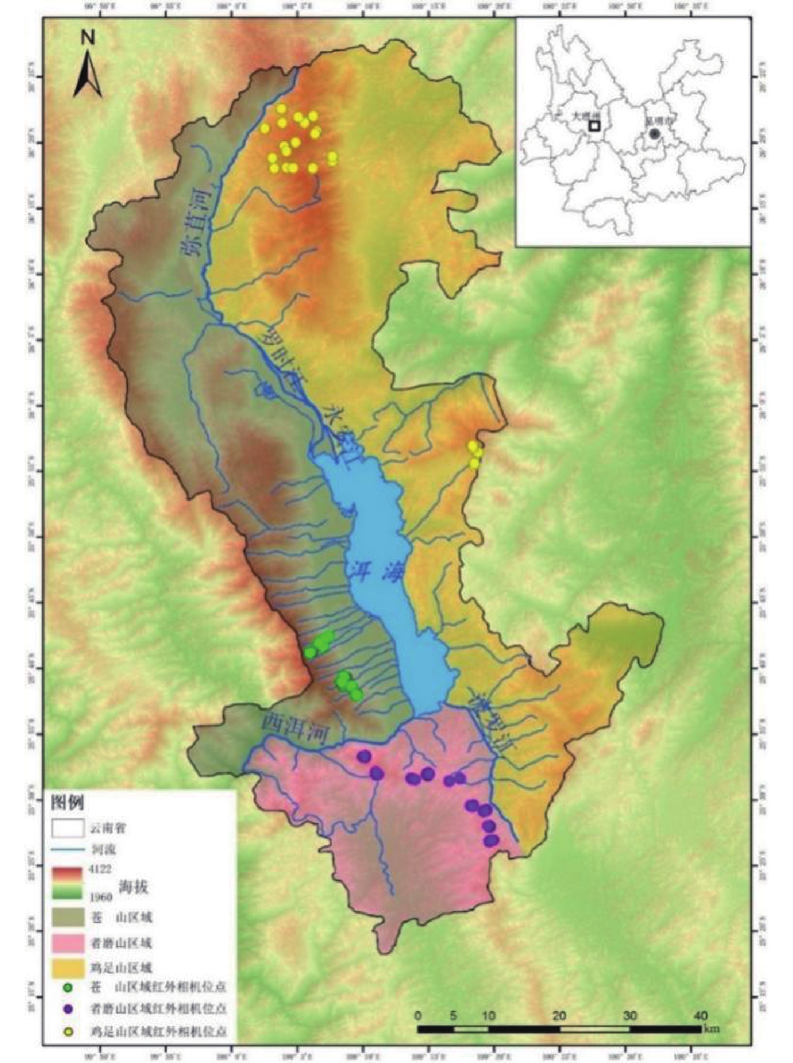
    • 洱海流域(25°25′ - 26°16′N, 99°32′ - 100°27′E)为澜沧江、元江以及金沙江三大水系的分水岭[26],纵跨大理白族自治州的大理市和洱源县,流域面积2 565 km2。洱海属澜沧江水系,湖面面积约有252 km2,是云南省第二大淡水湖[27]。洱海以西为苍山,是横断山脉云岭山脉南端的主要山峰,最高达4 122 m,有着明显的垂直气候差异,从山脚至山顶有着四种不同的气候类型:亚热带、暖温带、温带、寒温带,雨热同期,干湿季分明,其东坡植被以云南松、华山松、苍山冷杉为代表的针叶林为主[21]。以东为鸡足山,位于大理白族自治州宾川县内,为国家4 A级景区,是中国十大佛教名山之一,海拔最高达3 300 m,其气候炎热干燥,少雨干旱,植被类型多为常绿针阔叶林以及灌木丛[28]。北部的马鞍山海拔最高达3 700 m,属亚热带季风气候,其植被类型主要以针、阔叶林为主。而以南为者磨山,最高海拔为2 800 m,为低纬度高原季风气候,主要植被有杜鹃林、云南松林、灌木林等[29]。者磨山有着云南省首个、全国海拔最高的风电场,电机沿着山脊南北走向分布,一条公路串联各个单电机。研究分别以西洱河—下关坝子、波罗江—凤仪坝子、北三江—洱源坝子为界,将洱海流域分为三个区域,洱海以西的区域主要以苍山为主,南部区域以者磨山为主,东部区域以鸡足山、马鞍山(以下简称鸡足山)为主(见图1)。

      Figure 1.  Study area and camera traps stations

    • 采用红外触发相机技术分别于2017年2月—2017年4月,2018年4月—2018年12月,2020年3月—2020年9月期间在苍山、者磨山、鸡足山2 300~3 700 m海拔区间内的积累的、兼顾其他研究的红外相机获取的数据。其中苍山40台,者磨山56台,鸡足山24台(见表1)。苍山的相机均安装在东坡,海拔区间为2 300至3 500 m。在者磨山北坡、南坡2 300至2 900 m海拔段内各设置4个垂直距离为200m的样方,每个样方内安装7台相机,每台相机间距离大约100m。鸡足山的相机来自海拔2 600至3 700 m区间内20个2×2 km的网格,每个网格内2个固定调查位点,使用1台红外相机进行调查点轮换安装,另外在海拔2 500至2 900 m区间内以每台相机海拔垂直高度相差100 m左右,安装了4台相机(见图1)。所有相机均安装在距地面高0.5-1.5 m之间的树上,以拍摄地面为主,未放置引诱剂。在布设相机时记录每台相机布设位点的经纬度、植被类型、海拔等其他信息。所安装的红外相机型号为Ltl Acorn 6210、Ltl Acorn 6310,红外相机拍摄设置为灵敏度中,连续拍2张照片后录像10 s。每隔3-4个月检查一次各相机的工作情况,更换储存卡及电池。

      区域 布设台数 相机工作日 鸟兽独立有效照片 植被类型 海拔区间/m
      苍山 40 4 004 947 针叶林、针阔混交林 2 348—3 405
      者磨山 56 5 290 2 542 阔叶林、针叶林、针阔混交林 2 339—2 809
      鸡足山 24 2 924 675 竹林、阔叶林、针叶林 2 505—3 633

      Table 1.  Camera traps placement information

    • 布设的120台红外相机中,最终回收正常工作相机103台。共累计监测了12 218个有效工作日,共获取67 230张照片,将红外相机收回后导出照片数据并用CTIMCS软件[30]进行物种识别,获得物种的种类、名称、数量、拍摄时间等信息。参照《中国鸟类分类与分布名录(第3版)》[31]、《中国鸟类野外手册》[32]、《中国鸟类观察手册》[33]以及《中国兽类野外手册》[34],对拍摄到的大中型地面鸟兽物种进行鉴定。物种的保护级别以及濒危等级分别参照了《国家重点保护野生动物名录》(http://www.forestry.gov.cn)和IUCN红色名录(https://www.iucnredlist.org/)。除去人、无法辨认的夜间小型啮齿类动物照片、空拍照片及无效照片后,共获得了10 686张野生动物照片,以及3 479张牛、马、羊、狗家养动物的照片。

      将每台红外相机在野外连续正常工作24 h作为1有效工作日。每台红外相机在30min内拍摄到同一物种则将其定义为同一独立有效照片(independent photographs,IP);30 min内的相邻照片中含有不同种个体或是能够分辨个体特征的同种不同的个体也作为独立有效照片[35]

      使用R软件的iNEXT软件包[36],使用稀疏曲线估计苍山、者磨山、鸡足山三个区域内红外相机所记录到的全部物种、鸟类以及兽类的物种多样性。

      通过查阅王彦平等发表的中国鸟类的生活史和生态学特征数据集与Birds of the World 、Encyclopedia of Life(EOL)网站获取了目标鸟兽的功能性状。兽类共选取了6个功能性状,鸟类选取了4个功能性状(见表2)。这些功能特征不仅与物种在生态系统中的作用有关,同时还体现了物种对环境条件的响应[37],也与物种在自然中对资源的利用相关[38]。其中,鸟兽的体重性状为该物种成年雌雄个体体重平均值,单位为Kg;兽类每窝产仔数性状为该物种每窝产仔数平均值,单位为个;将鸟类的食物类型、觅食层与取食行为性状和兽类的活动时间、日常饮食性状转化为数字1和0,即1表示有,0表示无;兽类的地面利用与社会体系性状同样使用数字1和0表示。基于以上数据,使用R软件的FD软件包[39],计算三个区域鸟类、兽类五个主要的功能多样性指数,即功能丰富度指数(Functional richness index, FRic)、功能均匀度指数(Functional evenness index, FEve)、功能歧异度指数(Functional divergence index, FDiv)、Rao二次熵指数(Rao's quadratic entropy index, RaoQ)和功能分散度指数(Functional dispersion index, FDis)。

      功能性状 兽类 鸟类 数据来源
      体重 /Kg /Kg 1.https://eol.org/pages;2.https://birdsoftheworld.org/bow/home; 3.王彦平, 宋云枫, 钟雨茜,等. 中国鸟类的生活史和生态学特征数据集[J]. 生物多样性, 2021, 29(9):5.
      每窝产仔数 /个 ———
      活动时间 白天 ———
      黄昏
      夜间
      日常饮食/食物类型 脊椎动物 杂食
      无脊椎动物 食虫
      水果/种子 食谷
      叶子/树枝/树皮 食肉
      草根/块茎
      地面利用 是(1)否(0)具有攀爬能力 ———
      社会体系 独居(0)、群居(1) ———
      觅食层 ——— 地面
      下层林木
      中层林木
      冠层林木
      空中
      取食行为 ——— 拾取
      探取
      跳跃取食
      出击

      Table 2.  Functional traits used to calculate the functional diversity of birds and mammals

      通过计算相对丰富度指数(relative abundance index, RAI)来评估物种相对种群数量[40, 41],计算公式为:

      其中Ai代表第i种动物的独立有效照片数,T代表有效相机工作日总数。

      利用三个区域鸟兽物种RAI进行非参数置换相似性检验(Analysis of Similarities, ANOSIM),计算三个区域鸟兽、鸟类以及兽类的R值(ANOSIM statistic R)及p值,分析三个区域之间群落组成是否具有显著差异;其中−1 < R < 1,当R > 0,越接近1表示区域间群落差异越大,区域内各个位点群落相似性越大;R = 0表示区域间群落没有差异;当R < 0,越接近﹣1表示区域间群落差异越小,区域内各个位点群落相似性越小[42]

      使用R软件的permute软件包[43],采用非度量多维尺度分析(non-metric multidimensional scaling, NMDS)方法分析三个区域的鸟兽群落结构差异。在物种多样性、相似性检验以及群落结构差异分析中,由于红外相机安装于近地面不能拍摄到大多数鸟类,因此鸟类仅选用了雉科、噪鹛科、鸫科等地面活动鸟类进行数据分析,此外大部分夜间小型啮齿类动物难以鉴定,因此剔除了树鼩科、松鼠科、鼠科等小型兽类后进行数据分析。

    2.   结果
    • 研究共鉴定得到98种鸟兽,兽类6目17科25种,鸟类6目23科73种(附录)。其中,有国家一级保护动物2种,为黑颈长尾雉(Syrmaticus humiae)、林麝(Moschus berezovskii),国家二级保护动物有白腹锦鸡(Chrysolophus amherstiae)、白鹇(Lophura nycthemera)、红腹角雉(Tragopan temminckii)、红喉山鹧鸪(Arborophila rufogularis)、环颈山鹧鸪(Arborophila torqueola)、勺鸡(Pucrasia macrolopha)、血雉(Ithaginis cruentus)、大噪鹛(Ianthocincla maximus)、橙翅噪鹛(Trochalopteron elliotii)、猕猴(Macaca mulatta)、中华斑羚(Naemorhedus caudatus)、斑林狸(Prionodon pardicolor)、豹猫(Prionailurus bengalensis)、赤狐(Vulpes vulpes)、小熊猫(Ailurus fulgens)、亚洲黑熊(Ursus thibetanus)、黄喉貂(Martes flavigula) 17种,被IUCN红色名录列为濒危(EN)的有小熊猫、林麝2种,被列为易危(VU)的有中华斑羚、亚洲黑熊2种,被列为近危(NT)的有黑颈长尾雉、红腹角雉、猪獾(Arctonyx collaris) 3种。相对丰富度(RAI)最高的5种地面鸟类为白腹锦鸡(17.96)、红头噪鹛(Trochalopteron erythrocephalum,1.22)、长尾地鸫(Zoothera dixoni,1.21)、紫啸鸫(Myophonus caeruleus,1.05)、血雉(0.92),RAI最高的5种大中型兽类为赤麂(Muntiacus muntjac,7.09)、小麂(Muntiacus reevesi,4.05)、果子狸(Paguma larvata,3.21)、野猪(Sus scrofa,1.74)、马来豪猪(Hystrix brachyura,1.71)(附录1)。

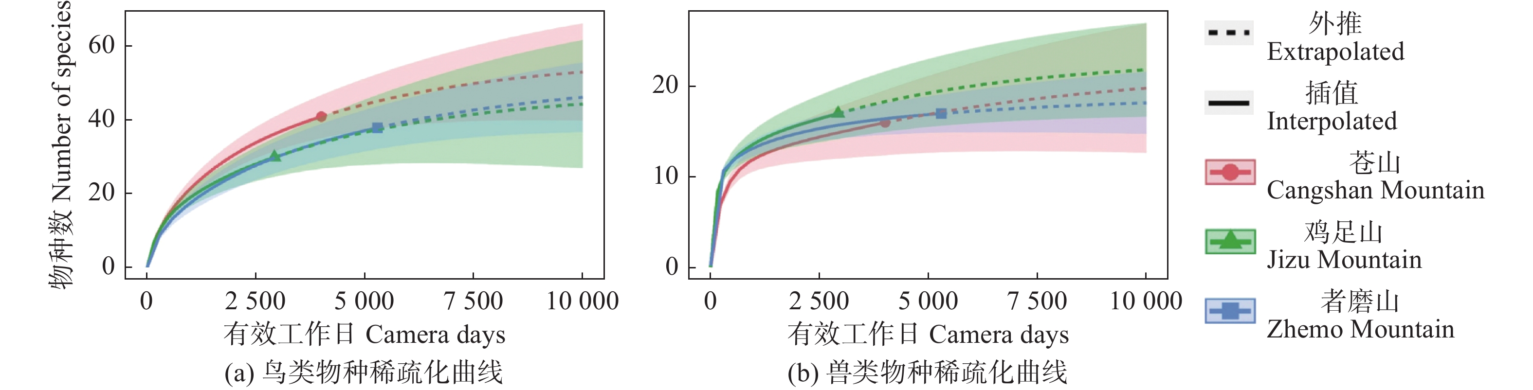
    • 通过稀疏化曲线对三个区域物种数估计,得出鸟类物种数估计值苍山为57.067 ± 11.036,者磨山为51.997 ± 9.898,鸡足山为47.994 ± 14.383;兽类物种数估计值为苍山21.999 ± 7.216,者磨山19.000 ± 3.741,鸡足山22.998 ± 7.224。三个区域鸟兽物种数无显著差异(见图3)。

      Figure 3.  Species rarefaction curves of birds and mammals in the three areas

      从功能多样性上看,鸟类与兽类功能丰富度指数均为鸡足山高于苍山高于者磨山。鸟类的功能均匀度指数同样也是鸡足山高于苍山高于者磨山,而兽类的功能均匀度指数则相反,为者磨山最高,鸡足山最低。苍山的鸟类功能歧异度指数高于另外两区域,而兽类功能歧异度指数则低于另外两区域。鸡足山Rao二次熵指数高于另外两区域(见表3)。

      区域功能丰富度
      FRic
      功能均匀度
      FEve
      功能歧异度
      FDiv
      Rao二次熵
      RaoQ
      功能分散度
      FDis
      鸟类
      苍山270.6960.7270.0230.101
      鸡足山280.7980.6980.0340.156
      者磨山230.4610.6950.0080.060
      兽类
      苍山120.6210.9030.1000.313
      鸡足山130.5570.9540.1030.319
      者磨山110.7020.9250.0970.308

      Table 3.  Index of functional diversity

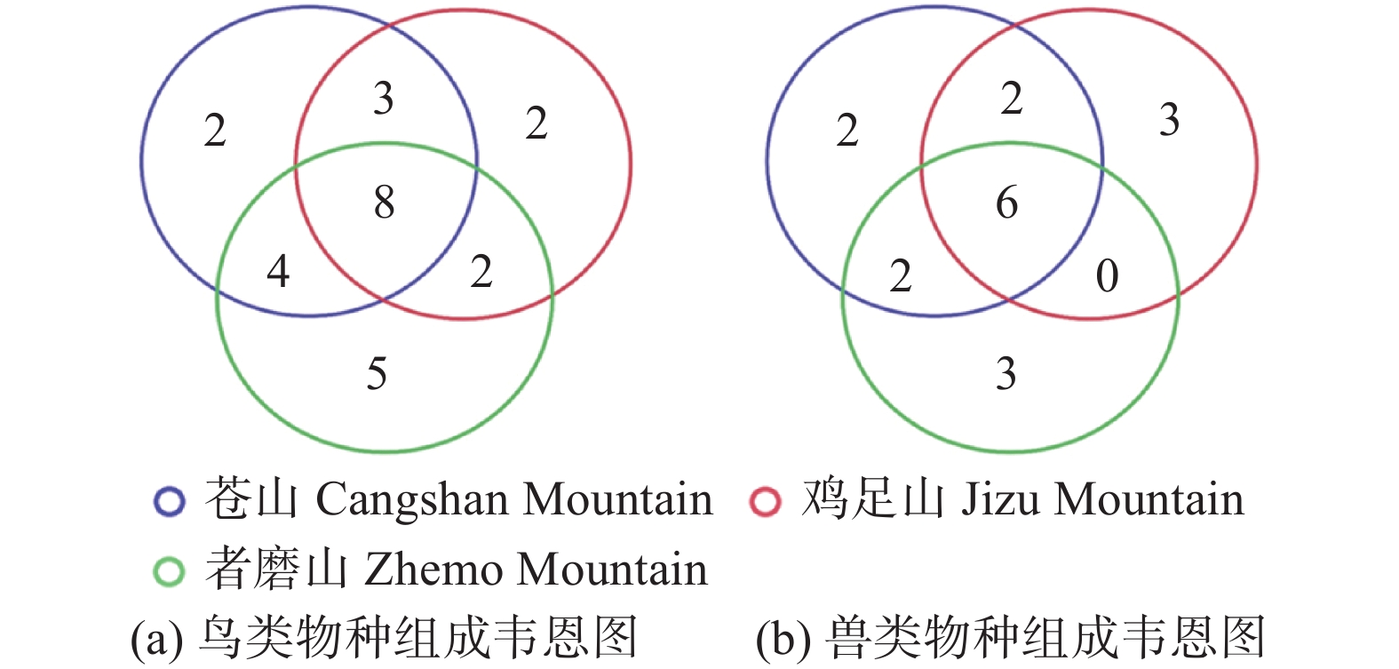
      从物种组成上看,苍山共记录到17种地面鸟类、12种大中型兽类,者磨山共记录到19种地面鸟类、11中大中型兽类,鸡足山共记录到15种地面鸟类、11种大中型兽类,其中三个区域共同鸟类8种、大中型兽类有6种。苍山与者磨山共同调查到的地面鸟类有4种:灰翅噪鹛(Ianthocincla cineracea)、白鹇、棕颈钩嘴鹛(Pomatorhinus ruficollis)、红头噪鹛,大中型兽类有2种:小熊猫、黄腹鼬(Mustela kathiah),苍山与鸡足山共同调查到的地面鸟类有3种:红腹角雉、灰头鸫(Turdus rubrocanus)、血雉,大中型兽类有2种:黄鼬(Mustela sibirica)、林麝,者磨山与鸡足山共同调查到的地面鸟类有2种:灰翅鸫(Turdus boulboul)、乌鸫(Turdus mandarinus),无共同调查到的大中型兽类。宝兴歌鸫(Turdus mupinensis)、纯色噪鹛(Trochalopteron subunicolor) 2种地面鸟类仅在苍山调查到,环颈山鹧鸪、红喉山鹧鸪、虎斑地鸫(Zoothera dauma)、黑颈长尾雉、雉鸡(Phasianus colchicus) 5种地面鸟类仅在者磨山调查到,勺鸡、矛纹草鹛(Pterorhinus lanceolatus) 2种地面鸟类仅在鸡足山调查到,中华斑羚、亚洲黑熊2种大中型兽类仅在苍山调查到,小麂、斑林狸、鼬獾(Melogale moschata) 3种大中型兽类仅在者磨山调查到,猕猴、赤狐、猪獾3种大中型兽类仅在鸡足山调查到(见图4)。通过非参数置换相似性检验分析,三个区域间鸟类物种组成差异极显著(Global R = 0.3696,p = 0.001),其中鸡足山和者磨山差异较小(R = 0.1277,p = 0.014),三个区域间兽类物种组成均存在极显著差异(Global R = 0.3679,p = 0.001)。

      Figure 4.  Venn diagram of species composition of birds and mammals in the three areas

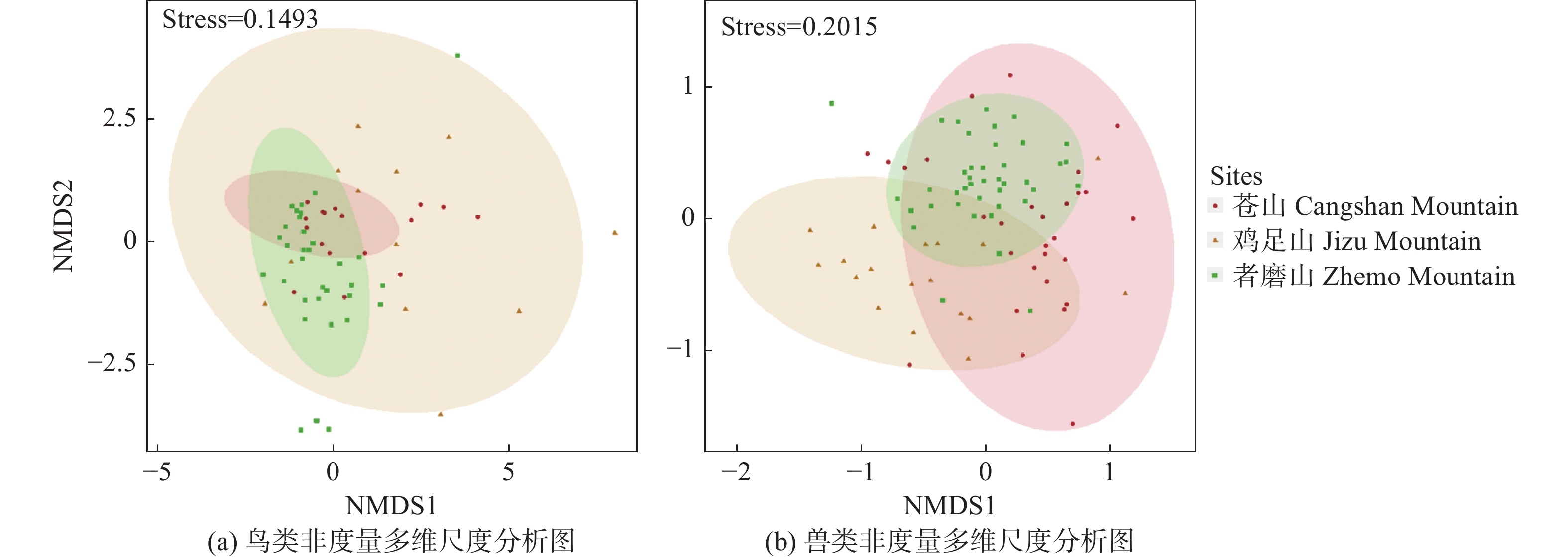
      对三个区域的地面鸟兽群落结构差异进行NMDS分析发现在地面鸟类方面,鸡足山位点间群落差异较大;三个区域都有一定的差异,但都存在群落相似的位点。三个区域的兽类群落间均存在一定差异,其中者磨山内部的差异相对较小(见图5)。

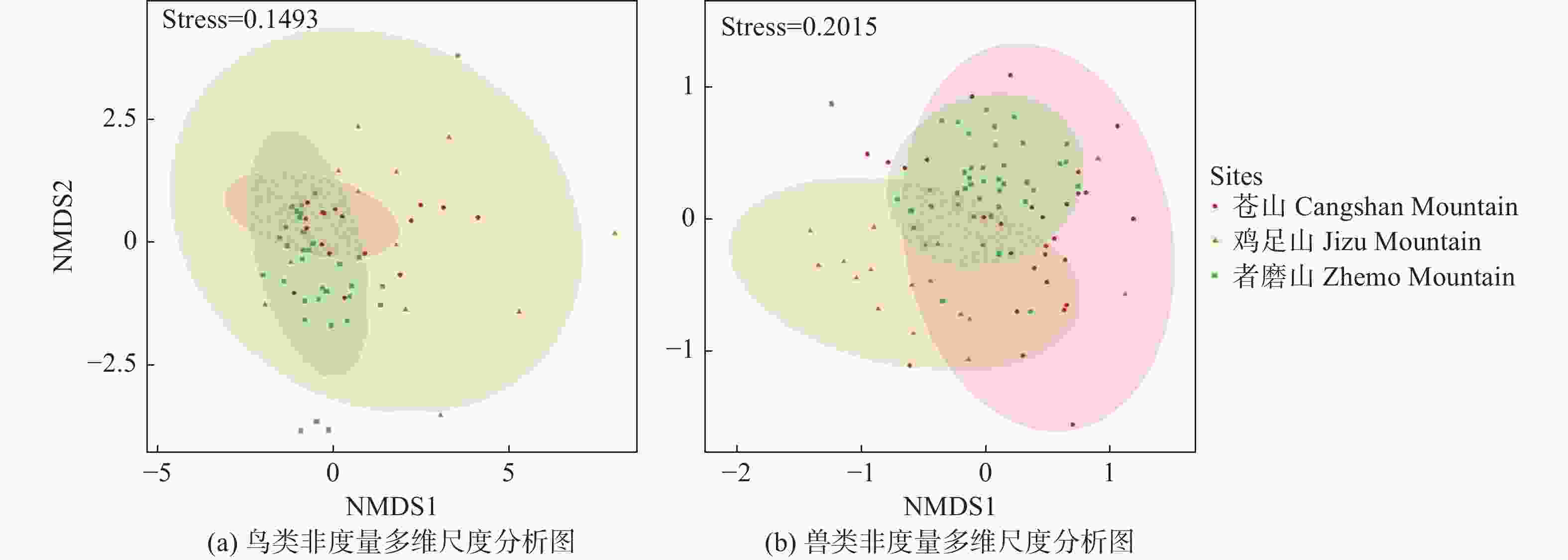
      Figure 5.  Non-metric multidimensional scaling of birds and mammals in the three areas

    3.   讨论
    • 从保护物种上看,除了苍山记录到国家二级保护物种亚洲黑熊和中华斑羚外,者磨山以及鸡足山也都监测到了保护物种。而国家一级保护动物黑颈长尾雉、国家二级保护动物斑林狸、红喉山鹧鸪、环颈山鹧鸪仅在者磨山被记录到,国家二级保护动物血雉、勺鸡、猕猴、赤狐仅在鸡足山记录到。除此之外,国家一级保护动物林麝、国家二级保护动物红腹角雉为苍山和鸡足山的共有物种,国家二级保护动物白鹇、小熊猫为苍山和者磨山的共有物种,而豹猫、黄喉貂、白腹锦鸡、大噪鹛、橙翅噪鹛5种国家二级保护动物则是三个区域的共有物种。

      三个区域的物种多样性没有显著的差异,但功能多样性存在较大差异。从功能多样性上,除了兽类的均匀度指数者磨山最高,鸟类的功能歧异度指数苍山最高外,各指数均为鸡足山最高。在苍山和者磨山中,各个多样性指数除了兽类的功能均匀度指数和歧异度指数,均为苍山高于者磨山。这显示鸡足山物种间的功能差异更大,对各类资源的利用程度要高于其他两个区域。这可能是由于鸡足山调查到了特有的竹林生境,某些物种的功能与其他物种尤为不同。者磨山的海拔跨度仅有400m左右,还不到其他区域的一半,另外较强的干扰也可能会导致物种不能利用一部分的生态位,这可能解释了者磨山较低的功能多样性。

      三个区域鸟兽均具有较多的特有物种,在群落结构上也有显著的差异,除了某些物种可能还未被调查完全,这可能是由于三个区域间的人类活动以及河流本身的阻隔作用所导致。早在公元7世纪初,洱海流域便出现了“六诏”,分别为位于洱海之北的浪穹诏、邆赕诏、施浪诏,南部的蒙巂诏、蒙舍诏,东部的越析诏[44]。洱海流域内最初人类活动以砍伐森林为主,后由于大量外地移民的迁入,人类活动逐步转变为农业耕作,后来采矿业也渐渐发展[18]。时至今日,高原湖泊独特的自然地理条件以及生态服务功能,使其在经济发展、生态文明建设,特别是旅游业发展中发挥着举足轻重的作用[45]。考虑到三个区域的特有种,除了个别物种,如血雉依赖于高山生境,大多数并不依赖于某种特定的栖息地,因而我们推测长期的栖息地改造和人类聚居区的屏障作用等直接或间接地阻隔了这三个区域物种之间的交流,使其产生了一定的分异。

      综上所述,洱海流域的三个区域都存在较高的特有种和保护物种的分布,而它们之间的群落和功能都存在一定的差异。建议对各个区域,特别是人类干扰较大的非保护区采取长期监测和一定的保护管理措施,并进行更多地研究以阐明其分布格局及其形成机制。

Reference (45)

Catalog

    /

    DownLoad:  Full-Size Img  PowerPoint
    Return
    Return