


-
全球气候变化、栖息地减少、外来物种入侵、环境污染等环境因素使全球物种多样性面临严重威胁[1]。确定并优先保护物种多样性与特有性高的地区有利于合理分配有限的资源,因此物种多样性空间分布格局成为生态学和生物地理学研究的一个热点问题,也是保护生物学确定多样性热点和保护重点的重要依据之一[2]。其中,物种多样性在环境梯度上的转变是生物多样性空间分布格局关注的重点。
纬度和海拔梯度的共同作用,几乎决定了物种的空间分布。海拔梯度被认为是影响生物多样性分布格局的决定性因素之一[3]。海拔梯度的环境因子异质性产生了多种物种多样性分布格局[4],与物种海拔梯度分布格局相关的研究中单峰曲线和单调下降型分布格局是最常见的两种类型[5],约有一半的研究结果呈现单峰曲线型分布格局[6]。除了海拔梯度分布格局外,纬度梯度分布格局也是生物多样性空间分布格局的重要因素[5]。在物种多样性的纬度梯度格局中,从高纬度到低纬度,生境越来越复杂,物种多样性越来越高;两极的物种多样性最低,热带雨林的物种多样性最高[7]。
研究物种多样性的纬度梯度、海拔梯度分布格局对物种多样性的监测和合理的保护措施的制定有着重要的意义。但目前同时讨论该两种环境梯度对生物多样性空间分布影响的研究较少,多数研究为一种环境梯度的讨论[8-10],只有蚊类等少数类群同时探索了纬度和海拔梯度分布模式,但并未比较海拔和纬度梯度的影响[11]。
高黎贡山位于云南西北部和西藏东南部的中缅边境,属于横断山系重要组成部分地理位置为24.56°—28.22°N,98.08°—98.50°E,海拔4 000 m以上。高黎贡山地区地势起伏大,横跨纬度较大,南北距离较长,以得天独厚的区位优势造就了大批珍稀动植物,具有较为明显的生物多样性特征[12]。从低海拔到高海拔,高黎贡山植被类型包含常绿阔叶林、硬叶常绿阔叶林、落叶阔叶林、暖性针叶林、温性针叶林、稀树灌木草丛、灌丛、草甸、高山流石滩、高原湖泊水生植被[13]。现有关于高黎贡山区域的调查研究大都着眼于全局范围内物种资源的概况[14-18],而对各分区特有环境下的多样性分布格局缺乏关注。鸟类存在于食物链的多个营养级中,生存环境多样,对环境变化较敏感,且相比较其他动植物类群,鸟类的分类及分布资料的数据收集程序相对简单、齐全。由此可见,鸟类是生物多样性监测的重要指示类群[19-20]。有研究显示高黎贡山地区鸟类种数在海拔梯度上呈单峰型垂直分布格局,但峰值与研究区域有关,且高黎贡山中段峰值出现在2300~2800 m[16],德宏州峰值位于500~2500 m[21]。在纬度梯度上,高黎贡山地区相邻纬度间鸟类群落组成更相似[22]。
以高黎贡山为研究区域,在海拔梯度和纬度梯度上对鸟类多样性进行调查和分析,旨在阐明高黎贡山区域纬度和海拔梯度上鸟类多样性变化趋势。此外,纬度梯度变化1°和海拔梯度变化100 m带来的温度变化趋势均为0.6℃[23],而温度是植被变化的主要因素。通过比较鸟类物种组成在纬度上1°的变化趋势和海拔上100 m的变化趋势,来探讨海拔和纬度梯度对鸟类物种组成的影响。期望能补充高黎贡山地区鸟类物种分布格局的认识,并且对纬度和海拔共同影响下的高生物多样性区域提供保护方案参考。
-
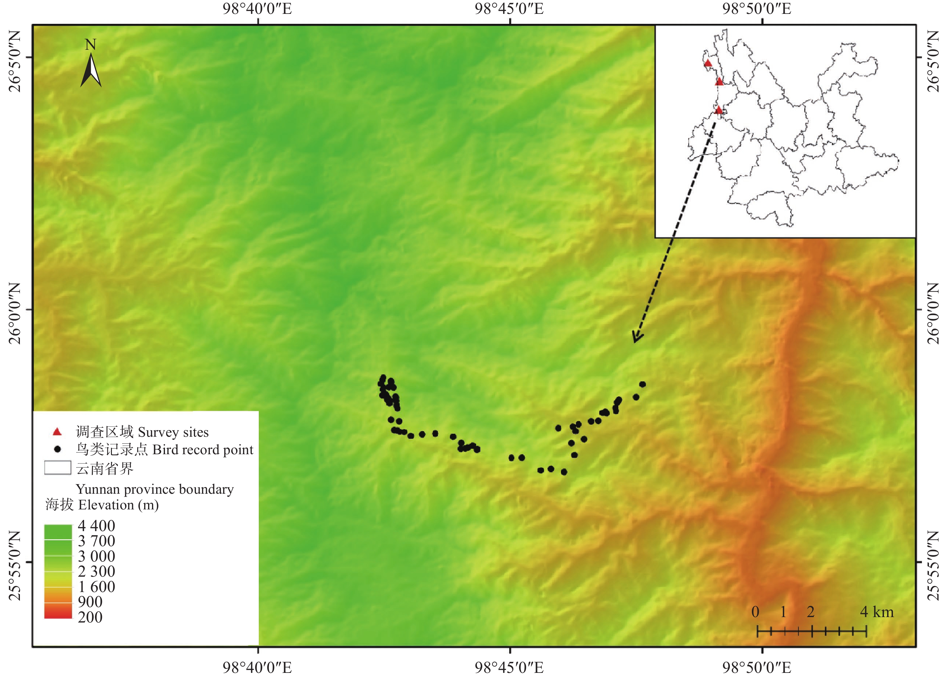
研究区域位于云南省境内高黎贡山东坡,调查地点选在云南省高黎贡山东坡的姚家坪(纬度25.94°N,海拔2000~2400 m)、亚坪(纬度27.14°N,海拔2000~2400 m)和独龙江(纬度27.90°N,海拔2000~2400 m),三个地点近似分布于26°N、27°N和28°N 3个纬度(见图1)。

Figure 1. Location of survey sites and bird sample points
-
姚家坪、亚坪和独龙江每个地点的2000~2400 m海拔段,每100 m划分一个海拔段,共5个海拔段:2000~2099 m(以下简写为2000 m海拔段),2100~2199 m(2100 m海拔段),2200~2299 m(2200 m海拔段),2300~2399 m(2300 m海拔段),2400~2499 m(2400 m海拔段)。每个海拔段内沿山路布设1000 m长鸟类观测样线。因姚家坪2000 m海拔段人类活动较强,原植被类型改变较大,没有设置样线。
-
2019年4月对整个区域或线路进行快速的预调查,了解整体的海拔、植被、生境分布情况及路况,并选定调查样线;2019年9月进行正式调查,调查时间一般为每天7:00~11:00及15:00~19:30两个时间段。根据实际情况调节调查时间(因山中天气多变,下雨原因会影响鸟类的活动状态及调查人员的观察视线)。调查人员4~5人,持双筒望远镜、单反相机及录音笔进行鸟类物种的识别并记录鸟类的物种名、数量、生境、海拔和经纬度。其中有些柳莺类因观测距离等原因难以辨认,均记为柳莺。
-
为分析鸟类物种多样性在海拔梯度上的变化,计算每个地点两两海拔段之间的Jaccard相似性指数;为分析鸟类物种多样性在纬度梯度上的变化,计算两两纬度地区相同海拔段之间的Jaccard 相似性指数;为对比鸟类物种多样性在海拔梯度上和纬度梯度上的变化,对比每个地点两两海拔段之间的Jaccard 相似性指数与两两纬度段之间的Jaccard 相似性指数。
Jaccard 相似性指数计算公式如下:
式中:a为只存在群落A中的物种数;b为只存在群落B中的物种数;c为A和B两群落都存在的物种数。
-
调查共记录到鸟类73种,525只次,其中在整个研究区域均有分布的物种有6种,为灰鹡鸰(Motacilla cinerea)、黄腹扇尾鹟(Chelidorhynx hypoxantha)、方尾鹟(Culicicapa ceylonensis)、金喉拟啄木鸟(Megalaima franklinii)、蓝喉太阳鸟(Aethopyga gouldiae)、栗头鹟莺(Seicercus castaniceps)。
-
调查记录到姚家坪鸟类为57种、亚坪为25种、独龙江20种,姚家坪和亚坪共有物种数为18种,Jaccard 相似性指数为0.180;亚坪和独龙江共有的物种数为6种,Jaccard 相似性指数0.118;姚家坪和独龙江共有的物种数为11种,Jaccard 相似性指数0.125(见图2);三个地点均有分布的物种6种,为灰鹡鸰、黄腹扇尾鹟、方尾鹟、金喉拟啄木鸟、蓝喉太阳鸟、栗头鹟莺。对比不同地区相同海拔段的鸟类物种组成,在较低纬度的姚家坪和亚坪之间Jaccard 相似性指数相对较高,而较高纬度的亚坪和独龙江,以及纬度差较大的姚家坪和独龙江之间Jaccard 相似性指数极低(见表1)。
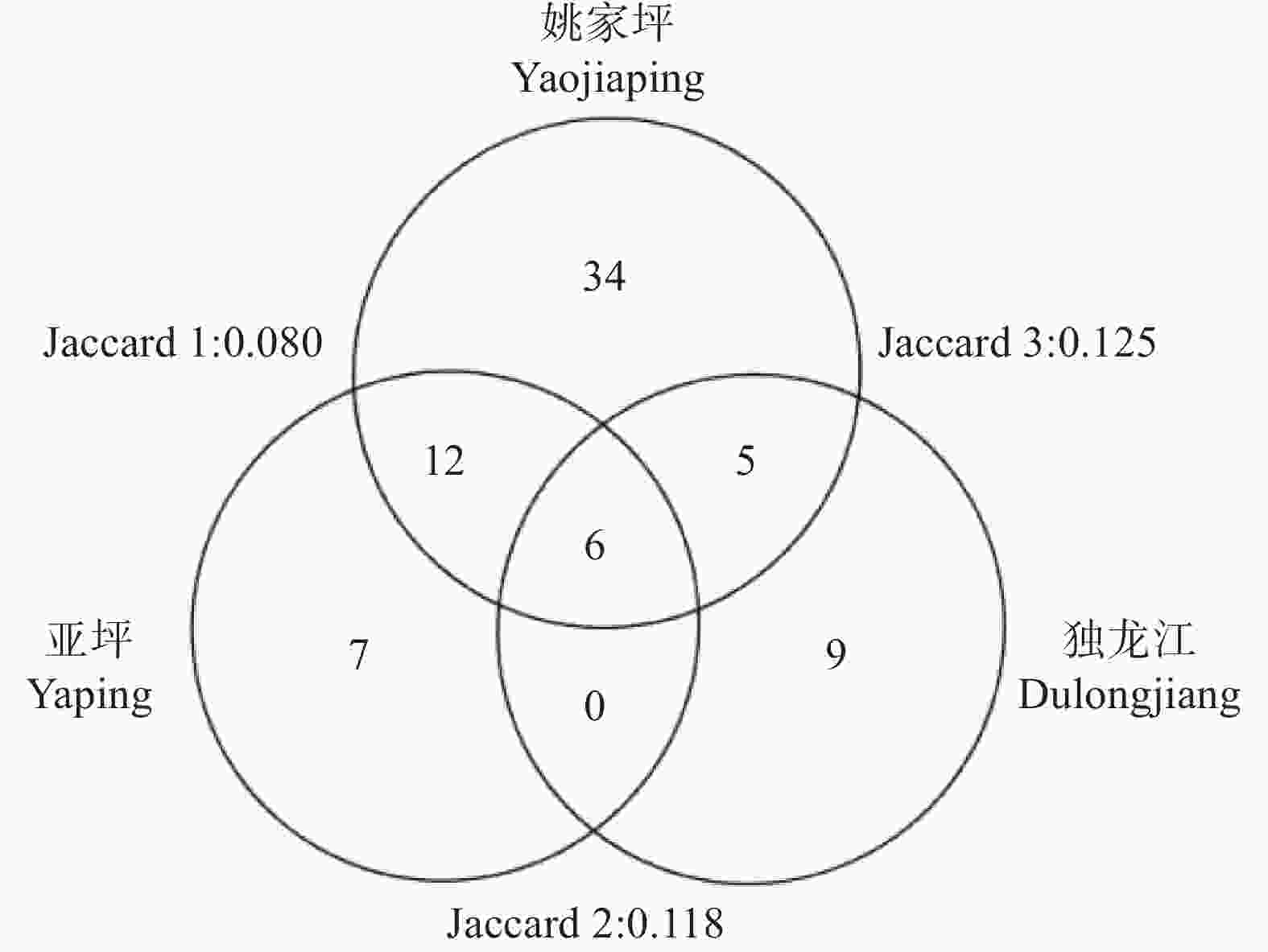
Figure 2. Number of bird species of three investigation sites at different latitudes and Jaccard similarity index between two sites
海拔段 姚家坪-亚坪 亚坪-独龙江 姚家坪-独龙江 2000 m — 0.111 — 2100 m 0.083 0.000 0.000 2200 m 0.075 0.000 0.000 2300 m 0.000 0.000 0.069 2400 m 0.146 0.000 0.000 Table 1. Jaccard similarity index between two sites at the same altitude in three investigation sites
-
三个调查地点,物种丰富度峰值出现的海拔段不同,沿海拔梯度变化的趋势也不同。姚家坪2200 m海拔段物种最丰富,为35种;亚坪2400 m海拔段物种最丰富,为19种;独龙江2300 m海拔段物种最丰富,为16种(见表2)。在姚家坪,2200 m和2400 m海拔段Jaccard 相似性指数最高,为0.119;在亚坪2100 m和2400 m海拔段海拔段Jaccard 相似性指数最高,为0.167;在独龙江2200 m和2300 m海拔段Jaccard 相似性指数最高,为0.091(见表3)。
海拔段 姚家坪 亚坪 独龙江 2000 m — 4 4 2100 m 5 7 1 2200 m 35 3 0 2300 m 15 3 16 2400 m 17 19 1 Table 2. Distribution of bird species richness along the elevations in each investigation site
比较的两海拔段 姚家坪 亚坪 独龙江 2000-2100 — 0.083 0.000 2000-2200 — 0.000 0.000 2000-2300 — 0.000 0.091 2000-2400 — 0.042 0.000 2100-2200 0.024 0.167 0.000 2100-2300 0.048 0.000 0.000 2100-2400 0.000 0.161 0.000 2200-2300 0.091 0.000 0.000 2200-2400 0.119 0.083 0.000 2300-2400 0.059 0.043 0.000 Table 3. Jaccard similarity index of bird species between two altitudes in each investigation site
姚家坪地区2100 m和2200 m海拔段均有分布的物种有1种,即长尾山椒鸟(Pericrocotus ethologus),Jaccard 相似性指数0.024;2100 m和2300 m海拔段均有分布的物种有1种,即大山雀(Parus major),Jaccard 相似性指数0.048;2200 m和2300 m海拔段均有分布的物种有5种,即橙斑翅柳莺(Phylloscopus pulcher)、红喉姬鹟(Ficedula albicilla)、红尾水鸲(Rhyacornis fuliginosus)、黄颈凤鹛(Yuhina flavicollis)和火尾希鹛(Minla ignotincta),Jaccard 相似性指数0.091;2200 m和2400 m海拔段均有分布的物种有7种,即白鹡鸰(Motacilla alba)、橙斑翅柳莺、方尾鹟(Culicicapa ceylonensis)、红尾伯劳(Lanius cristatus)、黄腹扇尾鹟(Chelidorhynx hypoxantha)、铜蓝鹟(Eumyias thalassinus)、西南冠纹柳莺(Phylloscopus reguloides),Jaccard 相似性指数0.119;2300 m和2400 m海拔段均有分布的物种有2种,即橙斑翅柳莺和丽色奇鹛(Heterophasia pulchella),Jaccard 相似性指数0.059。其中橙斑翅柳莺在多个海拔段出现。
亚坪地区2000 m和2100 m海拔段均有分布的物种有1种,即黄腹扇尾鹟,Jaccard 相似性指数0.083;2000 m和2400 m海拔段均有分布的物种有1种,即黄腹扇尾鹟,Jaccard 相似性指数0.042;2100 m和2200 m海拔段均有分布的物种有2种,即西南冠纹柳莺和方尾鹟,Jaccard 相似性指数0.167;2100 m和2400 m海拔段均有分布的物种有5种,即西南冠纹柳莺、灰喉柳莺(Phylloscopus maculipennis)、大山雀、黄腹扇尾鹟、方尾鹟,Jaccard 相似性指数0.161;2200 m和2400 m海拔段均有分布的物种有2种,即西南冠纹柳莺、方尾鹟,Jaccard相似性指数0.083;2300 m和2400 m海拔段均有分布的物种有1种,即长尾山椒鸟,Jaccard 相似性指数0.043。其中黄腹扇尾鹟和西南冠纹柳莺在多个海拔段出现。
独龙江2000 m和2300 m海拔段2000~2300 m均有分布的物种有2种,即灰鹡鸰和黄腹扇尾鹟,Jaccard 相似性指数0.091。其他海拔段均未有相同的物种分布。
-
海拔梯度上,姚家坪100 m相邻的海拔段之间Jaccard 相似性指数分别为0.024、0.091、0.059;亚坪100 m相邻的海拔段之间Jaccard 相似性指数分别0.083、0.167、0.000、0.043;独龙江100 m相邻的海拔段之间Jaccard 相似性指数均为0;总体平均值为0.044 (见表3)。同一海拔段上,纬度相邻的姚家坪和亚坪的Jaccard 相似性指数为0.083、0.075、0.000、0.146;亚坪和独龙江的Jaccard 相似性指数为0.111、0.000、0.000、0.000,总体平均值为0.046(见表1)。整体分析表明,海拔梯度上的Jaccard 相似性指数近似等于纬度梯度,即鸟类物种构成在海拔梯度和纬度梯度上的转换率相似。
-
根据Jaccard 相似性原理,当Jaccard 相似性指数为0~0.25时,表示极不相似;当Jaccard 相似性指数为0.25~0.50时,表示中等不相似;当Jaccard 相似性指数为0.50~0.75时,表示中等相似;当Jaccard 相似性指数为0.75~1.00时,表示极相似[24]。本研究中,各个环境梯度之间鸟类群落的Jaccard 相似性指数均较低,表明该区域鸟类物种组成在海拔和纬度上变化都极大。
研究区域的鸟类物种多样性在纬度梯度上呈现出较为明显的单调递减模式,随着纬度的增加,鸟类物种数量逐渐减少,这与前人研究的结果一致。鸟类的生长繁殖对食物、筑巢场所等有一定的要求[25],鸟类对环境比较敏感,且活动范围广。低纬度地区,食物资源丰富,生境稳定性相对高纬度地区较稳定,不易发生改变,纬度由低到高鸟类物种丰富度存在种数减少的基本趋势[26]。此外,高黎贡山相邻低纬度地区间的相似性比高纬度相似性高,可能是由于低纬度地区的环境条件更相似。不相邻纬度两地间的相似性指数比相邻纬度间的相似性指数略高,可能是研究区域存在较多分布范围广的物种。
在海拔梯度上,姚家坪和独龙江地区鸟类物种多样性呈现出单峰曲线分布格局,亚坪地区物种多样性在中等海拔较低。姚家坪、亚坪、独龙江鸟类物种数峰值分别出现在2200 m海拔段、2400 m海拔段、2300 m海拔段。不同纬度上,鸟类在海拔梯度上的分布格局存在差异,可能与局域生境有关。除纬度和海拔等较大的空间尺度,局域生境对物种分布格局影响也较大[27-28]。低纬度的姚家坪、亚坪在海拔梯度上的Jaccard 相似性指数较高,而较高纬度独龙江在海拔梯度上的Jaccard 相似性指数极低;即随着纬度的增加,鸟类物种组成在海拔梯度上相似性逐渐降低。可能是在高纬度地区,环境因素在海拔梯度上变化更快。
纬度和海拔的共同作用决定一个地区气候和环境条件。在海拔相同的情况下,纬度的差异将会使两地区的综合地理有明显差异;在纬度相同的情况下,海拔的差异也将会使两地区的综合地理有明显差异。本研究的三个调查地点在100 m海拔梯度上的鸟类群落相似性指数的总体平均值与1°纬度梯度相似,说明鸟类物种组成在纬度上1°的变化趋势和海拔上100 m的变化趋势是一样的。对比姚家坪和亚坪两地鸟类的Jaccard 相似性指数和姚家坪、亚坪相同海拔段鸟类的Jaccard 相似性指数,较低纬度的姚家坪和亚坪两地均有分布的物种,分布在相同海拔段的较多;而在姚家坪和独龙江之间、以及和亚坪和独龙江之间,均有分布的物种多数分布在不同的海拔段。表明高黎贡山较低纬度地区之间,海拔的差异对物种组成的影响相对较小。
不同环境梯度上的生境差异,使鸟类群落组成不同,栖息地空间异质性和复杂性导致了鸟类群落物种的多样性[29]。在高黎贡山地区,纬度与海拔共同的作用塑造了该地区复杂多样的地理特征[30],整个区域鸟类群落在环境梯度上的转换率极高,物种组成差异极大。因此,高黎贡山的生物多样性保护应尽量包含整个区域。对于纬度和海拔梯度跨度较大、环境异质性高的区域,应综合考虑多个环境梯度上生物多样性的组成和转变,以制定合理的保护措施。
Spatial Distribution Pattern of Bird Species Diversity on Latitude and Altitude Gradient in Gaoligong Mountains
doi: 10.12172/202208300001
- Received Date: 2022-08-30
- Available Online: 2023-03-04
- Publish Date: 2023-06-25
-
Key words:
- Gaoligong Mountain /
- Bird species diversity /
- Latitude gradient /
- Altitude gradient
Abstract: The Latitude and altitude are the most important environmental gradients that affect the distribution pattern of biodiversity. It is of practical significance to focus on the impact of latitude and altitude gradient on regional biodiversity protection,but there are few related studies at present. In biodiversity hotspot Gaoligong Mountains, bird species in Yaojiaping (25.94°N), Yaping (27.14°N) and Dulong (27.90°N) were surveyed by transect line method at 2000~2400 m a.s.l., species richness and Jaccard similarity index were used to analyze the distribution pattern of bird diversity on altitude and latitude gradients, and the effects altitude gradient and latitude gradient on bird diversity were compared. The results showed that: (1) On the latitude gradient, the bird species number in lowest latitude Yaojiaping was the highest, and the Jaccard similarity index of bird species among the three sites was quite low, and the similarity between Yaojiaping and Yaping in low latitude was higher; (2) On altitude gradient, the peak of bird species richness in Yaojiaping, Yaping and Dulongjiang occured at 2200 m , 2400 m and 2300 m respectively, the Jaccard similarity index of bird species among different altitude segments were quite low in each of the three sites; (3) The Jaccard similarity index on the latitude gradient was similar with that on the altitude gradient. The results showed that the Jaccard similarity index of bird communities in the altitude and latitude spatial gradient of Gaoligong Mountain was low, and the composition of bird communities in the whole region was very different. Therefore, the protection policy need to consider multiple regions and habitats in order to achieve better biodiversity protection. In addition, the change of bird community composition in 100 m altitude gradient in this area was equivalent to 1 latitude gradient, which confirmed the geographical law of climate and environment change in latitude and altitude gradient.


 DownLoad: